Scalable Algorithmic Methods for Simulating Heavy-Rain Events

Abstract
We motivate and demonstrate simulation and evaluation of large-scale, fine-grained hydrodynamic flows, triggered by heavy-rain events. We show significant progress for simulating time-dependent, high-resolution runoff in large-scale heavy-rain scenarios, based on different geometry-based algorithmic speedup techniques. This enables us to address a second challenge: How can we deal with the instability of precipitation events, which are notoriously difficult to predict with good accuracy?
Keywords and phrases:
Heavy-rain events, hydrodynamic flows, scalable simulation, applied computational geometry, sensitivity analysisCategory:
Media ExpositionCopyright and License:
![[Uncaptioned image]](x1.png) © Sándor P. Fekete, Phillip Keldenich, Michael Perk, and Tobias Wallner; licensed under Creative Commons License CC-BY 4.0
© Sándor P. Fekete, Phillip Keldenich, Michael Perk, and Tobias Wallner; licensed under Creative Commons License CC-BY 4.0
2012 ACM Subject Classification:
Theory of computation Computational geometry ; General and reference ExperimentationAcknowledgements:
We thank our cooperation partners at SCALGO, in particular, Morten Revsbæk, Thomas Mølhave and Matthias Rav. In memoriam Lars Arge.Funding:
The work described here was part of project EXDIMUM, supported by the German Federal Minstery of Research, Technology and Space, grant number 02WEE1631A.Editors:
Hee-Kap Ahn, Michael Hoffmann, and Amir NayyeriSeries and Publisher:
 Leibniz International Proceedings in Informatics, Schloss Dagstuhl – Leibniz-Zentrum für Informatik
1 Introduction
Throughout human history, natural disasters have been a significant threat [17]. Both frequency and extent of heavy-rain events have increased in recent time, as observed by [10] in 2020 for Germany, Thus, the development of efficient and stable tools for hydrodynamic modeling has been an active field for decades, both in research and in product development [12]. The use of high-resolution elevation models is important for capturing terrain details that can have a major impact on the runoff behavior of surface water [11]; however, the high-resolution simulation is computationally highly intensive, making it difficult to employ it for larger areas, especially in early warning systems [13, 8]. Accordingly, many existing tools offer different compromises between modeling details, preprocessing time, and computation time. Scalable approaches for these important tasks are based on combining a number of algorithmic tools, including methods from computational geometry. While previous success stories (most notably by Arge et al. [4, 14, 3, 6, 5, 1, 2, 7]) have made significant progress on stationary flood levels in largely flat terrain, the problem of flooding with time-dependent water flow in sloped terrain remains computationally demanding even with modern tools and commercial software.
Beyond all these efforts for scalable simulation methods, a second, potentially even bigger challenge looms: How can we deal with the unreliable nature of one of the most crucial inputs for any such model – the precipitation data, in time and space? Acquiring this time-dependent input with an accuracy similar to that of a finely resolved, static terrain is highly challenging, and even more difficult when it comes to forecasting such precipitation. As a consequence, computational methods from meteorology, computational physics or modern AI will likely continue to struggle to obtain reliable, fine-grained input, due to the instability of critical weather phenomena. This also implies that real-time intervention, as well as preemptive measures, will continue to suffer from a lack of reliable forecasting of the ensuing runoff.
2 Study Area and Hydraulic Modeling
While our methodological work is applicable to any region with sufficiently detailed terrain data, the main focus area of our work is a polygonal domain centered on Goslar, Germany, and lies entirely within the federal state of Lower Saxony (Niedersachsen). Elevations increase from ca. above sea level (a.s.l.) in the Oker valley north of Goslar to almost a.s.l. in the southern sector according to Copernicus EU-DEM v1.1 [9].
Testing, improving and benchmarking of our simulations was performed with the commercial solver TUFLOW HPC version 2025.1.0, which is a 1D/2D hydraulic modeling software that solves the depth-averaged Navier-Stokes equations, also known as the shallow water equations, to simulate the flow of water over a terrain. TUFLOW uses an explicit finite volume solution with a square grid, whose cells might vary in size. Further details on the numerical scheme can be found in the TUFLOW manual [16] and in our full paper [15].
3 Enhancing Simulations
In general, there are two main challenges when simulating large areas with high resolution. Firstly, the memory footprint of the simulation becomes prohibitively large, making it infeasible to run the simulation on current hardware. Secondly, the runtime of the simulation also eventually grows beyond a reasonable time frame. This is often countered by using coarser resolution models, which can lead to a loss of accuracy in crucial areas.
Our work [15] is based on two algorithmic improvements. Firstly, we have developed a subdivision algorithm that partitions the terrain into smaller regions that can be simulated independently, thus reducing the memory footprint of the simulation; see Figure 1. Secondly, we use a quadtree refinement approach that (given areas and desired resolution as inputs) automatically refines the mesh in critical regions. A key contribution of our work is the analysis of what regions require refinement and how much refinement is necessary to maintain accuracy while minimizing computational cost; see Figure 2. Both approaches can be combined to enable large-scale simulations on modern hardware.
4 Outcomes
There are two main outcomes of our work: (I) progress for simulating time-dependent, high-resolution runoff in large-scale heavy-rain scenarios, based on the two algorithmic approaches described in Section 3. In combination with state-of-the-art commercial software and powerful computing devices, these approaches can achieve simulation times that are significantly shorter than the duration of the simulated events for modestly sized regions (on the order of tens of square kilometers) at meter-scale resolution. The exact times depend on many factors, such as the amount of precipitation, condition numbers, terrain characteristics and the presence of 1D model elements such as culverts, which are also modeled. For very large domains (such as our area of interest of in the mountainous Harz region) at resolution, the limitations of available GPU memory prohibits running a simulation on the entire region at once. Our subdivision technique makes such a simulation feasible, requiring roughly three weeks to simulate a five-hour heavy-rain event on a single machine and eleven days when parallelization is used to the full extent possible with the given dependency graph. Combining this with our grid refinement technique reduces the required time to three days on a single machine and to around hours when parallelized, see Figure 3.
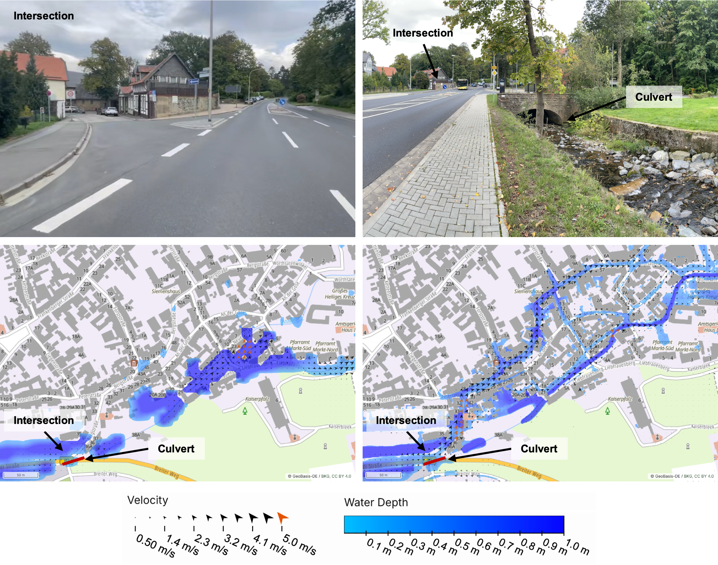
This progress enables us to demonstrate how the second challenge can be addressed: (II) We use our new computational capabilities to conduct a large-scale, multifaceted sensitivity analysis, providing insights into different scenarios for possible time-dependent runoff and flooding when varying the input precipitation for our study area. This makes it possible to identify both regions of stability (for which the outcomes are largely unchanged under input variations) as well as critically unstable locations (for which the outcome may change significantly under input variations). In particular the latter is of crucial value for effective disaster mitigation: Knowing where relatively small changes can make a significant difference in the outcome is highly valuable when deciding where to invest limited resources with the greatest impact. We demonstrate the viability of this approach by identifying such a critical location for our study area, see Figure 4.
5 The Video
After introducing the global challenges and previous work from Computational Geometry (culminating in SCALGO), the video describes the challenges and approaches to dealing with time-dependet, dynamic scenarios, such as in our study region in the Harz mountains. After visualizing the two main outcomes from above, we highlight how these improvements make it possible to identify critical locations, where small changes can have a large effect.
References
- [1] Pankaj K. Agarwal, Lars Arge, Thomas Mølhave, and Bardia Sadri. I/O-efficient efficient algorithms for computing contours on a terrain. In Symposium on Computational Geometry (SoCG), pages 129–138, 2008. doi:10.1145/1377676.1377698.
- [2] Pankaj K. Agarwal, Lars Arge, and Ke Yi. I/O-efficient batched union-find and its applications to terrain analysis. In Symposium on Computational Geometry (SoCG), pages 167–176, 2006. doi:10.1145/1137856.1137884.
- [3] Pankaj K. Agarwal, Lars Arge, and Ke Yi. I/O-efficient batched union-find and its applications to terrain analysis. ACM Transactions on Algorithms, 7(1):11:1–11:21, 2010. doi:10.1145/1868237.1868249.
- [4] Lars Arge, Aaron Lowe, Svend C. Svendsen, and Pankaj K. Agarwal. 1D and 2D flow routing on a terrain. ACM Transactions on Spatial Algorithms and Systems, 9(1):3:1–3:39, 2023. doi:10.1145/3539660.
- [5] Lars Arge and Morten Revsbæk. I/o-efficient contour tree simplification. In International Symposium on Algorithms and Computation (ISAAC), pages 1155–1165, 2009. doi:10.1007/978-3-642-10631-6_116.
- [6] Lars Arge, Morten Revsbaek, and Norbert Zeh. I/O-efficient computation of water flow across a terrain. In Symposium on Computational Geometry (SoCG), pages 403–412, 2010. doi:10.1145/1810959.1811026.
- [7] Lars Arge and Norbert Zeh. I/O-efficient strong connectivity and depth-first search for directed planar graphs. In IEEE Symposium on Foundations of Computer Science (FOCS), page 261, 2003. doi:10.1109/SFCS.2003.1238200.
- [8] Kate Bradbrook, Simon Waller, and Dave Morris. National floodplain mapping: datasets and methods–160,000 km in 12 months. Natural hazards, 36:103–123, 2005. doi:10.1007/s11069-004-4544-9.
- [9] Copernicus Digital Elevation Model (DEM). Global 30 m, version 1.1. https://registry.opendata.aws/copernicus-dem/, 2021. European Space Agency & European Commission (accessed 2025-06-23).
- [10] Detlef Deumlich and Andreas Gericke. Frequency trend analysis of heavy rainfall days for germany. Water, 12(7):1950, 2020. doi:10.3390/w12071950.
- [11] RJ Hardy, PD Bates, and MG Anderson. The importance of spatial resolution in hydraulic models for floodplain environments. Journal of Hydrology, 216(1-2):124–136, 1999. doi:10.1016/S0022-1694(99)00002-5.
- [12] Neil M Hunter, PD Bates, S Neelz, G Pender, I Villanueva, NG Wright, D Liang, Roger Alexander Falconer, B Lin, S Waller, et al. Benchmarking 2d hydraulic models for urban flooding. In Proceedings of the institution of civil engineers-water management, volume 161, pages 13–30, 2008. doi:10.1680/wama.2008.161.1.13.
- [13] Shubham M Jibhakate, PV Timbadiya, and PL Patel. Flood hazard assessment for the coastal urban floodplain using 1d/2d coupled hydrodynamic model. Natural Hazards, 116(2):1557–1590, 2023. doi:10.1007/s11069-022-05728-7.
- [14] Thomas Mølhave, Pankaj K. Agarwal, Lars Arge, and Morten Revsbæk. Scalable algorithms for large high-resolution terrain data. In International Conference and Exhibition on Computing for Geospatial Research & Application (COM.Geo), pages 20:1–20:21, 2010. doi:10.1145/1823854.1823878.
- [15] Michael Perk, Phillip Keldenich, Tobias Wallner, and Sándor P Fekete. Hydrodynamic flows during heavy rain events: Scalable algorithmic methods for simulation and sensitivity analysis. EGUsphere, pages 1–33, 2026.
- [16] TUFLOW. Tuflow user manual, 2025. URL: https://docs.tuflow.com/.
- [17] United Nations Office for Disaster Risk Reduction. Global assessment report on disaster risk reduction 2025: Resilience Pays: Financing and Investing for our Future. UN, 2025. URL: https://www.undrr.org/gar/gar2025.