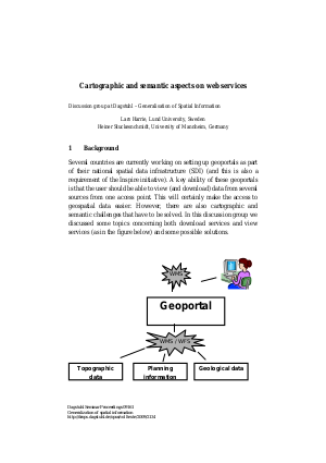
Harrie, Lars ;
Stuckenschmidt, Heiner
Cartographic and semantic aspects on web services
Abstract
Several countries are currently working on setting up geoportals as part of their national spatial data infrastructure (SDI) (and this is also a requirement of the Inspire initiative). A key ability of these geoportals is that the user should be able to view (and download) data from several sources from one access point. This will certainly make the access to geospatial data easier. However, there are also cartographic and semantic challenges that have to be solved. In this discussion group we discussed some topics concerning both download services and view services and some possible solutions.
BibTeX - Entry
@InProceedings{harrie_et_al:DSP:2009:2134,
author = {Lars Harrie and Heiner Stuckenschmidt},
title = {Cartographic and semantic aspects on web services},
booktitle = {Generalization of spatial information },
year = {2009},
editor = {S{\'e}bastien Musti{\`e}re and Monika Sester and Frank van Harmelen and Peter van Oosterom},
number = {09161},
series = {Dagstuhl Seminar Proceedings},
ISSN = {1862-4405},
publisher = {Schloss Dagstuhl - Leibniz-Zentrum fuer Informatik, Germany},
address = {Dagstuhl, Germany},
URL = {http://drops.dagstuhl.de/opus/volltexte/2009/2134},
annote = {Keywords: Geopertals, integration, semantic technologies}
}
|
Keywords: |
|
Geopertals, integration, semantic technologies |
|
Seminar: |
|
09161 - Generalization of spatial information
|
|
Issue date: |
|
2009 |
|
Date of publication: |
|
21.09.2009 |